| Home | Kurse | Zoo Logik | Publikationen | Links | Webdesign | Kontakt | ZooLogic |
|
R Buckminster Fuller R Buckminster Fuller (1899 - 1983) war wohl eines der grössten Genies des 20. Jahrhunderts. Als Ingenieur ein Poet, als Designer ein Denker, als Forscher ein Künstler.
Von ihm stammen aber auch Wortschöpfungen wie "Synergie" oder "Think global - act local".
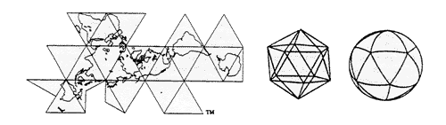
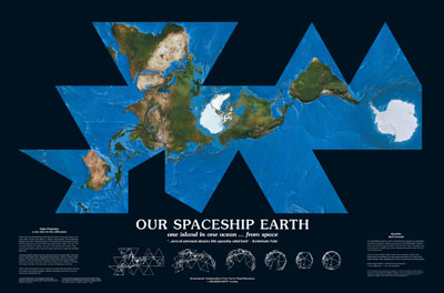
Dymaxion World Map "We are all astronauts on a spaceship earth" Die exakteste Darstellung der Oberfläche einer Kugel auf einer Fläche gelingt durch die Projektion der Kugeloberfläche auf die zwanzig gleichseitigen Dreiecke eines Ikosaeders, des fünften Platonischen Körpers. Dadurch werden die unvermeidlichen Verzerrungen minimiert und gleichmässig verteilt.
Durch eine geschicket Anordnung der Dreiecke erscheint "unser Raumschiff Erde" als "Eine Insel in einem Ozean".
Dieser Poster (ca. 95 x 63 cm) kann beim Buckminster Fuller Institute bestellt werden.
A New View for the New Millennium...A powerful tool for advancing humanitys option for success... "The projection used for this world map, also known as the Dymaxion Map, was created by Buckminster Fuller, distinguished mathematician, inventor and 20th century visionary. The map began as a sketch, The One-Town World in 1927. By 1954, after working on the map for several decades, Fuller finally had a satisfactory deck plan of the six and one half sextillion tons Spaceship Earth. The Dymaxion Map is the only flat map of the entire surface of the earth that reveals our planet as it really is an island in one ocean without any visible distortion of the relative shapes and sizes of the land areas, and without splitting any continents. Traditional world maps reinforce the elements that separate humanity and fail to highlight the patterns and relationships emerging from the ever evolving and accelerating process of globalization. Instead of serving as a precise means for seeing the world from the dynamic, cosmic and comprehensive viewpoint, the maps we use still cause humanity to appear inherently disassociated, remote, self-interestedly preoccupied with the political concept of its got to be you or me; there is not enough for both. The maps commonly in use today distort, exaggerate and divide the landmasses in their attempt to show the curved surface of the earth as a flat projection. Greenland appears as large or larger than the US and Australia, although itÕs actually much smaller. The massive continent of Asia usually does not fit unless divided. Antarctica is so grossly distorted that it appears as a ragged fringe on the bottom (of course, spheres dont have tops or bottoms). To be seen in their entirety, the polar-regions must be shown separately. Fullers intent was to emphasize how important it was to find effective ways for all humanity to see total Earth, [because] nothing could be more prominent in all the trending of all humanity today than the fact that we are soon to become world humans. He developed a powerful tool that could allow viewers to study; at a glance, the total synergetic significance of AirOcean economies and the alternate strategies for integrating all phases and states of energy resources towards the highest operative advantage of all world people. The computer assisted information/communication revolution has greatly enhanced our ability to store and transmit vast quantities of reliable data about social, environmental and economic trends. The opportunity before us is to convey this information without bias and distortion and in ways that allow ordinary people to visually grasp and intuitively understand the current predicament of the human experiment. The information/communication revolution has greatly enhanced our ability to store and transmit vast quantities of reliable data about social, environmental and economic trends. The opportunity before us is to convey this information without bias and distortion and in ways that allow ordinary people to visually grasp and intuitively understand the current predicament of the human experiment. By using the Dymaxion Map in combination with the enormous database resources and computer graphics available today, it is now highly feasible to accurately and clearly display the inventory of world resources, trends and needs in multiple dimensions. Only an accurate visual tool such as this can enable us to better see and forecast how human activity and other natural phenomenon effect the prospects for delivering high standards of living for all people on an ecologically sustainable basis. World maps and the information they impart can play an important role in shaping our perception of the responsibility we have as passengers on board our Spaceship Earth. In the Dymaxion Map, our disunity is obliterated, even for those to whom such an idea might have been inconceivable. Given a way to visualize the total planet with greater accuracy, we are better equipped to address the challenges to humanitys future." |
>> Buckminster Fuller Institute
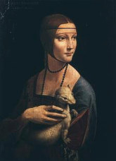
Leonardo da Vinci Ein anderes Genie seiner Zeit: Leonardo da Vinci
Die Dame mit dem Hermelin
|
|
Copyright © 2000 - 2005 by ZooLogic
- Mark Fischbacher - Trichtenhausenstrasse 45 - CH-8053 Zürich
|
Hintergrundbild: >> The Dymaxion World of R. Buckminster Fuller
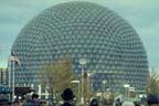 Weltweit
bekannt wurde er v.a. durch die gründliche Erforschug der Geodätischen
Kuppeln (Geodesic Domes) und den Bau des U.S.-Pavillons für die Weltausstellung
1967 in Montreal.
Weltweit
bekannt wurde er v.a. durch die gründliche Erforschug der Geodätischen
Kuppeln (Geodesic Domes) und den Bau des U.S.-Pavillons für die Weltausstellung
1967 in Montreal.